Corinthos Region Main Port
The commercial activities of Corinth main port are of great importance for entire Greece. The facilities serve the transportation of containers and they act supplementary to the respective services of Piraeus Port. The volume of traded products is constantly increasing as well as the tourist traffic. Both of these needs highlighted the weakness of existing infrastructure to offer an effective level of provided services, due to the lack of land area, depths and lengths of quay walls.
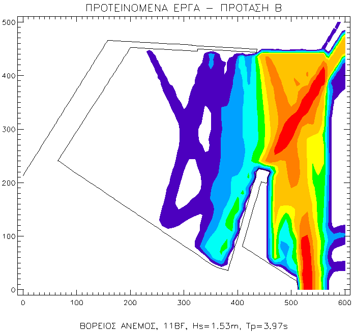
The upgrade of existing works was noted as crucial and thus, the former Harbor Treasury of Corinth Port, after holding a contest, contracted CNWAY the design of new port infrastructure that included new quay walls, inside the basin, in order to cover the commercial needs, as well as a new leeward mole for the berthing of cruise ships. Two layouts were implemented (A and B) with their main difference to be the orientation of the leeward mole, which "leans" with greater angle towards the port basin.
The total design was reviewed considering the prevailing wave conditions both in the entrance and inside the basin of the port. This review was realized by preparing a wave disturbance study through the implementation of the respective numerical model simulations.
The results of the study showed that, during the blowing of north and northeast winds, the case of the "turned" leeward mole towards the basin (layout Β) offers a significantly better protection and milder wave conditions in the basin, in comparison with the other layouts, including the existing one. The maximum acceptable wave disturbance for the port amounts to 0.9 meters. This limit is exceeded for only 1.5 days per year in layout B, while in layout A, it is respectively surpassed for nine days per year.
Study facts:
• Estimation of offshore wave characteristics using JONSEY model from Seaworks1 marine software suite
• Simulation of wave disturbance by the numerical PORTRAY from Seaworks3 marine software suite
• Three dimensional display of sea bed using AutoCad Civil3D from Autodesk, square mesh dimension 5mx5m along the windward mole and 10mx10m for the rest of the basin
• Implementation of simulation for three (3) layouts, existing and two new proposals
• Examination of two (2) wind directions, north (wind intensities of 11, 7 and 5bf) and northeast (wind intensities of 10, 7 and 5bf)