Velanidia Fishing Harbour – Lakonia Region
Location
Velanidia in Lakonia, is a small graphical village that is built along a steep cliff, on the west side of Krithina mountain and with view to the Mirtoo sea. The fishing harbour of the village is located in a small gulf in the east and it serves the fishing boats of the area.
Existing conditions
The existing facilities were built around 1960’s and they were expanded, many years later, in 2014. The expansion works were built in order to protect and increase the berths of the fishing boats. Their construction had direct impact in the form of the coastline of the gulf by causing erosion of the west edge of the beach as well as sedimentation of the basin.
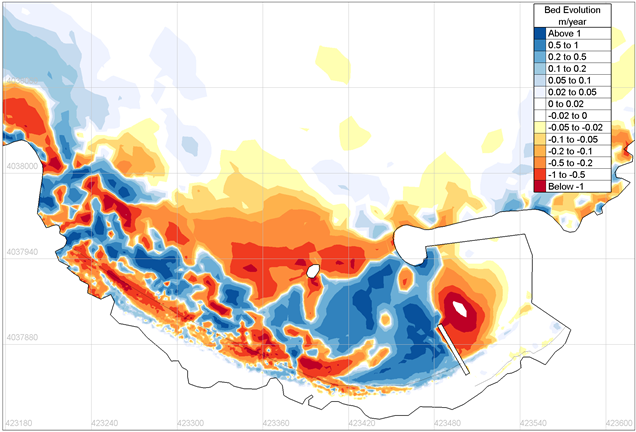
In order to determine the exact “coastal behavior” of the new works, the Municipal Harbor Treasury of Monemvasia assigned in 2014, CNWAY the preparation of the respective sediment transport study and the conceptual design of the appropriate works so as to address the sedimentation problem of the basin. The respective identification of the coastal area included, among others, the sampling and sieve analysis of seabed material in order to determine its grain size. These actions were followed by the preparation and implementation of the sediment transport simulation along the coastline.
The results of the study showed that, before the construction of the expansion works, the sediment was transported from east to west, as it was moving away from the fishing harbour. The presence of the new windward mole interrupted the transport mentioned before. At the same time, a significant quantity of sediment is transferred from west to east. These phenomena result in the entrapment of the sediment, inside the basin.
Proposed works
In order to face the problem, it was proposed to construct a groin, across and in the shadow of the new mole. The presence of the groin interrupts the sediment transport from west to east and its deposition inside the basin.
Study facts
• Estimation of offshore wave characteristics using JONSEY model from Seaworks marine software suite
• Simulation of coastal sediment transport using the TMS (Telemac-Mascaret System) numerical model suite. TMS is based on internal coupling of individual models of wave propagation (TOMAWAC), wave induced currents (TELEMAC2D) and sediment transport (SISYPHE)
• Mesh dimension 1,100mx1,000m, 9,600 nodes and 18,500 elements
• Implementation of simulation for two layouts (existing and new)
• One year simulation time, four (4) examined wind directions, E, NE, N, NW for wind intensities of 9 and 5bf for each direction