Palaikastro Fishing Harbour – Crete Island
The area of Palaikastro town, in eastern Lasithi of Crete Island, presents a significant tourist activity, especially during the summer. It is located near important sites of alternative tourism (Gorge of the Dead, Vai beach and the homonymous palm forest) and other beautiful beaches (Kouremenos, Kato Zakro, Chiona etc.). The fishing harbour, on the northern edge of Kouremenos Gulf, is the town’s anchorage and the only organized port facility along the east coastline of Crete. Thus, the entire fishing fleet of the area seeks shelter inside its basin which results in great congestion, despite the fact that the existing infrastructure cannot serve successfully the demanded number of boats and offers inadequate protection from south and southeast waves.
In view of the above difficulties, there was a proposal for a new design of expansion works. In order to review this design, the former Municipality of Itanos, in 2006, assigned CNWAY the preparation of a wave disturbance study, so as to determine and evaluate the wave conditions inside the basin, after the construction of the new works. The study was realized through the preparation and implementation of the respective numerical model simulations.
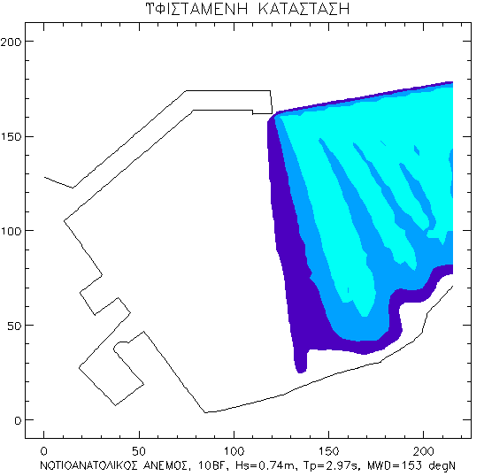
The results of the study showed that the proposed works offer an effective protection of the basin from south and southeast waves, in occasions when these winds blow with an intensity up to 10bf. A small disturbance, up to 0.5m, is observed in the entrance of the harbor and along the quay walls of the leeward mole. This disturbance is considered acceptable, in all respects, for fishing harbours.
Study facts:
• Estimation of offshore wave characteristics using JONSEY model from Seaworks1 marine software suite
• Calculation of local wave characteristics inside Kouremenos Gulf and at the harbour sea area with the numerical model MIKE21 NSW from DHI software suite
• Simulation of wave disturbance by the numerical PORTRAY from Seaworks3 marine software suite
• Three dimensional display of sea bed using AutoCad Civil3D from Autodesk, mesh dimension 12mx12m (Kouremenos Gulf) and 2.5mx2.5m (harbor sea area)
• Implementation of simulation for two layouts, existing and new
• Examination of two (2) wind directions, S and SE, for wind intensities of 10 and 6bf for both directions