Main Port of Thymena Island
Thymena is the second largest island of Fournoi-Korseoi Islands complex, placed in the eastern Aegean Sea, between Ikaria and Samos. The underdeveloped port facilities, along the east coastline and inside Limionari Gulf, cannot protect efficiently the fishing boats etc. that berth there from main waves, while it is impossible to serve larger ships for goods and passenger transportation. In order to solve these crucial problems, there was a new design of expansion works so as to upgrade the existing infrastructure. The review of the design, as of its impact on the morphology of the coastline, required the preparation of a sediment transport study. This study was assigned to CNWAY by the Prefecture of Samos in 2007.
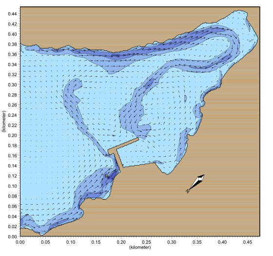
The geomorphological identification of the coastal area was done by in situ observations, sampling of seabed material, followed by sieve analysis, in order to determine the grain size. These actions were followed by the calculation of the offshore wave characteristics and finally, the preparation/implementation of the sediment transport simulation along the coastline, before and after the construction of the new works.
The results of the study showed that the scarce sediment which can be transported along the east and west coastlines, is heading towards the gulf cove. The proposed works, like the existing ones, stop the sediment transportation from northwest to southeast and this causes the erosion of the coastline in the south of the works and more specifically of two beaches that are located there. However, it must be mentioned that the expansion works decrease the pace of erosion of the first beach in the south and, in general, they have no impact on the formed beach of the gulf cove.
Study facts:
• Estimation of offshore wave characteristics using JONSEY model from Seaworks marine software suite
• Simulation of coastal sediment transport using the MIKE numerical mode suite and, specifically, models of setting the land-boundaries (coastline) and the water depths (ΜΙΚΕ21 PP), calculating local wave characteristics (MIKE21 NSW), wave induced currents (MIKE21 HD) and sediment transport (MIKE21 ST)
• The simulation area includes the whole Limionari Gulf
• Implementation of simulation for two layouts (existing and new)
• Examination of north and northeast wind directions and wind intensity of 6bf for each direction